
 And now for something completely different. We are heading South.
This is a new series in a very different part of the country for this blog: the American South. Mostly, the photos in this post and the posts to follow are from an almost three week drive I did in April from Brooklyn, New York, to Charleston, South Carolina, and back.
It was essentially a loop – from New York City I cut through southern New Jersey following I-95 and then I-295 to the Delaware River in the south, crossed over the Delaware Memorial Bridge and then drove through a bit of Delaware (it’s not a big state!) until I reached northern Maryland. That was it for the interstates for the next several weeks, unless it was absolutely necessary. Back roads, country highways and scenic byways: that’s what I look for on these road trips.
The journey in these posts will be the eastern shore of the Chesapeake Bay in Maryland, then Annapolis and northern Maryland, inland Virginia, inland North Carolina, South Carolina from the North Carolina state line all the way to Charleston and the Low Country, mostly coastal (“Tidewater”) North Carolina and Virginia on the return journey northward, a stop in Washington, D.C. (from a prior trip), Delaware again (this time with stopovers), New Jersey and back home.
The Deep South will have to wait for a future road trip (or trips). Truth be told, I don’t really know the Deep South at all other than bits of Georgia and New Orleans. I’d like to return and explore places like Georgia, Alabama, Mississippi and Louisiana. Not in the summer!
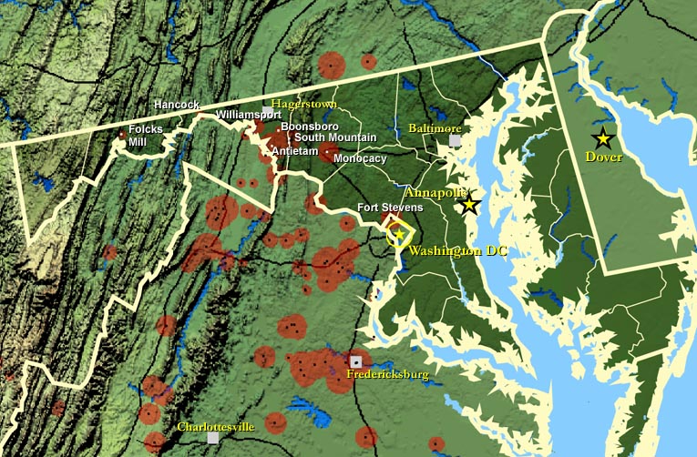
We’ll start the series in Maryland (in blue in the map on the vintage postcard below). Is it the South? Many tend to think of Maryland as the South (the US Census folks do), but I read that some southerners would not consider Maryland the South as such. Maryland did permit America’s great historic evil – slavery – and for that matter so did Delaware and Washington, D.C., but Maryland did not secede and remained with the Union along with Delaware. The historians note, however, that a lot of people there were sympathetic to the Confederate cause. As part of the Union, Maryland was not included in President Abraham Lincoln’s 1863 Emancipation Proclamation, and slavery wasn’t abolished there until 1864. According to Wikipedia Maryland contributed troops to both the Union (60,000) and the Confederate (25,000) armies. It was and remains a border state and has both a Northern feel and Southern feel. A lot seems to depend on the particular part of the state. I don’t claim to be an expert on Maryland (far from it) so I’ll leave the North vs. South debate about the state to others with greater knowledge on the subject.

Major battles during the American Civil War were fought in Maryland. In this post we’ll visit two battlefields, Monocacy and Antietam.
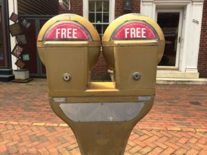 First, let’s get on the Chesapeake Country Scenic Byway – MD Route 213 on the Eastern Shore of Chesapeake Bay. It’s a lovely drive mostly through farming country with historic towns and villages and fine water views. If you click through, you will see a map. I stopped for lunch in Chestertown (founded 1706) which has a charming main street (high street) with lots of places to stop and to eat, plus the best parking meters ever. It was a grand spring day, and I sat outside at the old Hotel Imperial (see photo).
In the first few photos in the set you’ll see beautifully maintained historic buildings and a couple of derelict structures, too. That pretty much set the pattern for the next three weeks of driving. My very first photo of the road trip was that abandoned farmhouse on Route 213; over the course of the next weeks I would see many more ruins. If “Abandoned America” is your thing, there’s plenty of it in the South. There is also much beauty, plus tremendously historic cities, towns and villages, with many of them alive and well (especially in Virginia). In Maryland, I also saw quite a few lovingly maintained farms. One thing is for sure, this part of the country is incredibly photogenic.
My first overnight was in Annapolis. I didn’t spend a lot of time there, but I did get to do a walkabout at the United States Naval Academy. I was pleasantly surprised that with proper ID it’s possible for visitors to be admitted. It’s a very handsome campus. Here is the visitor information. There are guided tours; I walked around on my own.
Next stop for my second overnight was Frederick, Maryland. I got an early start for what was an ambitious day: the Monocacy National Battlefield at Frederick and then the Antietam National Battlefield at Sharpsburg both in one day. Northern Maryland and neighboring Virginia below it each has a number of Civil War battlefields and sites (see the dark red circles below). Monocacy and Antietam are among the most important.
The July 1864 Battle of Monocacy is known as “the battle that saved Washington, DC”. The Confederacy had what has been called a bold plan to turn the tide of the Civil War in their favor by capturing Washington, DC. It was a Union defeat that really was an important victory. The Union forces were greatly outnumbered, but (as the National Park Service site describes it) the federal forces fought gallantly to withstand the Confederate attacks along the banks of the Monocacy River long enough for General Ulysses S. Grant Union to get reinforcements to Washington, DC. Eventually the Union forces went into full retreat and the Confederates won the Battle of Monocacy, but the federal capital was saved. This was the last push north by Confederates in 1864 and one of the last engagements by the Southern forces on Union territory. Of 6,050 Federal troops in the battle, some 1,300 were killed, wounded, or missing in action. Of 14,000 Confederates involved, there were about 700 casualties. (Britannica.com).
Antietam. It’s hard to find the words. The September 1862 Battle of Antietam (also known as the Battle of Sharpsburg) between Confederate General Robert E. Lee’s Army of Northern Virginia and Union General George B. McClellan’s Army of the Potomac, near Sharpsburg and Antietam Creek, was part of the 1862 Maryland Campaign by the Confederates. It’s been called “the bloodiest day in American history”. After twelve hours of fighting on September 17, 1862, 23,000 soldiers were killed, wounded or missing out of the nearly 100,000 engaged. It was carnage. That’s nearly one quarter of all soldiers engaged in the battle; it’s an astounding number. The Union forces had halted Lee’s invasion of Maryland but at a very high cost. After the battle Lee’s army withdrew back across the Potomac to Virginia, thereby ending the Confederate Army of Northern Virginia’s first invasion into the North.
I remember when I visited nearby Gettysburg Battlefield in Pennsylvania for the first time. It was hard to imagine the death and suffering that took place there; similarly, as I gazed out at the former battle sites of Antietam, I struggled to picture what took place there on that awful day. Both are ultimately chilling places when one reflects on all that happened there.
As you can see from the photos, both the Antietam battlefield and national cemetery are beautifully preserved. On the day I was at Monocacy and Antietam, there was the occasional light shower, but otherwise it was a pretty spring day despite all those clouds you see in the photos. There was hardly anyone at either site (unlike the couple of times I visited Gettysburg over the years which draws a lot of people). I had expected Antietam to be more crowded given its importance. It really made a difference being at the various tour sites mostly on my own. As you can see, it is quite picturesque with many of the farms that existed in 1862 still there and seemingly unaltered. It’s in a more pristine state than other Civil War battlefields I have visited, although I haven’t been to that many. They are not something I seek out. Also, I have spent most of my life either in California or Europe – far away from US Civil War sites.
I didn’t visit any other battlefields on the drive; Antietam and Monocacy were more than enough.
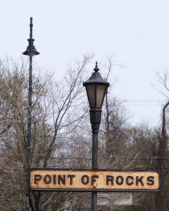
We will finish our short visit to Maryland with two stops very close to the Virginia state line: first, the handsome Victorian train station at Point of Rocks, Maryland (great name, no?), and next the lockhouse at Lock 29 along the Chesapeake & Ohio Canal. The C&O Canal operated from 1831 until 1924 along the Potomac River from Washington, D.C., to Cumberland, Maryland. After 1924 this historic canal was mostly abandoned. It was badly damaged by two huge floods in 1924 and 1936. Some of the waterway survives elsewhere as do some of the historic structures like this lockhouse.
It’s off to Virginia next which was a tremendously enjoyable part of the drive. The next overnight will be in Charlottesville. We will have a lot to see and do together in Virginia. See you again in a couple of weeks for the next post!
The photos follow below. Click on (or tap) an image to expand it (and use the arrow to the right on an expanded image to go through the set, if preferred over scrolling down in the post).
, MD Route 213 on the Eastern Shore of Chesapeake Bay.")
North of Kennedyville (Kent County), MD Route 213 on the Eastern Shore of Chesapeake Bay.

On MD Route 213 in Kent County on the Eastern Shore of Chesapeake Bay.

On MD Route 213 in Kent County on the Eastern Shore of Chesapeake Bay.

Chestertown on MD Route 213 in Kent County on the Eastern Shore of Chesapeake Bay.

Chestertown on MD Route 213 in Kent County on the Eastern Shore of Chesapeake Bay.

Chestertown on MD Route 213 in Kent County on the Eastern Shore of Chesapeake Bay.

Wye Mills in Talbot County, on MD Route 213 on the Eastern Shore of Chesapeake Bay.

Wye Mills in Talbot County, on MD Route 213 on the Eastern Shore of Chesapeake Bay.

Wye Mills in Talbot County, on MD Route 213 on the Eastern Shore of Chesapeake Bay.

Wye Mills in Talbot County, on MD Route 213 on the Eastern Shore of Chesapeake Bay.

Driving from Wye Mills to Queen Anne's County and the bridge to Annapolis, on the Eastern Shore of Chesapeake Bay.

Stribling Walk looking toward Mahan Hall, walking "the Yard", United States Naval Academy, Annapolis, Maryland
, United States Naval Academy, Annapolis, Maryland")
Buchanan House (home of the Superintendent), United States Naval Academy, Annapolis, Maryland

Ward Hall, United States Naval Academy, Annapolis, Maryland

Midshipmen at "the Yard" looking toward the Severn River, United States Naval Academy, Annapolis, Maryland

Tecumsah Court, United States Naval Academy, Annapolis, Maryland

Bancroft Hall, United States Naval Academy, Annapolis, Maryland

Inside Bancroft Hall, United States Naval Academy, Annapolis, Maryland
 near Gate 1, United States Naval Academy, Annapolis, Maryland")
“Captain’s Row” (Porter Road) near Gate 1, United States Naval Academy, Annapolis, Maryland
 near Gate 1, United States Naval Academy, Annapolis, Maryland")
“Captain’s Row” (Porter Road) near Gate 1, United States Naval Academy, Annapolis, Maryland

Midshipmen returning from a run, United States Naval Academy, Annapolis, Maryland

The Best Farm, Monocacy National Battlefield, Frederick, Maryland

The Best Farm, Monocacy National Battlefield, Frederick, Maryland

The road to the Thomas Farm, Monocacy National Battlefield, Frederick, Maryland

The Thomas Farm, Monocacy National Battlefield, Frederick, Maryland

Worthington House, Monocacy National Battlefield, Frederick, Maryland

The Thomas Farm, Monocacy National Battlefield, Frederick, Maryland

Antietam National Battlefield, Sharpsburg, Washington County, Maryland

Miller Farm, Antietam National Battlefield, Sharpsburg, Washington County, Maryland

Antietam National Battlefield, Sharpsburg, Washington County, Maryland

Mumma Farm, Antietam National Battlefield, Sharpsburg, Washington County, Maryland

Mumma Farm, Antietam National Battlefield, Sharpsburg, Washington County, Maryland

Antietam National Battlefield, Sharpsburg, Washington County, Maryland

Maryland State Monument, Antietam National Battlefield, Sharpsburg, Washington County, Maryland
 and 20th NY Volunteer Infantry Monument (right), Antietam National Battlefield, Sharpsburg, Washington County, Maryland")
NY State Monument (left) and 20th NY Volunteer Infantry Monument (right), Antietam National Battlefield, Sharpsburg, Washington County, Maryland

Antietam National Battlefield, Sharpsburg, Washington County, Maryland

8th Regiment Pennsylvania Reserves Monument, Antietam National Battlefield, Sharpsburg, Washington County, Maryland

Joseph Poffenberger Farm, Antietam National Battlefield, Sharpsburg, Washington County, Maryland

Joseph Poffenberger Farm, Antietam National Battlefield, Sharpsburg, Washington County, Maryland

The Dunker Church, Antietam National Battlefield, Sharpsburg, Washington County, Maryland
, Antietam National Battlefield, Sharpsburg, Washington County, Maryland")
Lower Bridge (Burnside's Bridge), Antietam National Battlefield, Sharpsburg, Washington County, Maryland

Antietam National Battlefield, Sharpsburg, Washington County, Maryland

Antietam National Cemetery, Sharpsburg, Washington County, Maryland

Private Soldier Monument, Antietam National Cemetery, Sharpsburg, Washington County, Maryland

Antietam National Cemetery, Sharpsburg, Washington County, Maryland

4th New York Volunteers Memorial, Antietam National Cemetery, Sharpsburg, Washington County, Maryland

Antietam National Cemetery, Sharpsburg, Washington County, Maryland
 in southwestern Frederick County, Maryland")
Point of Rocks Railroad Station (1873) in southwestern Frederick County, Maryland
 in southwestern Frederick County, Maryland")
Point of Rocks Railroad Station (1873) in southwestern Frederick County, Maryland

Lock 29 on the Chesapeake and Ohio Canal Towpath, Hagerstown, Maryland

Lander Lock House at Lock 29 on the Chesapeake and Ohio Canal Towpath, Hagerstown, Maryland

Lock 29 on the Chesapeake and Ohio Canal Towpath, Hagerstown, Maryland

Lock 29 on the Chesapeake and Ohio Canal Towpath, Hagerstown, Maryland