
 This is it. The third and final post in the series on the Southern California coast. Last time we got as far as Point Mugu in the southwestern corner of Ventura County. Today we’ll start out in Ventura (after a brief stop for some fish tacos in Oxnard on the way), work our way through Santa Barbara County and finally make it as far as Shell Beach just north of Pismo Beach in San Luis Obispo County.
This will be mostly coast. In some places there’s no other choice but to head inland where the road north leaves the coast, such as the Pacific Coast Highway (PCH) from Point Mugu to Oxnard in Ventura County, and 101 and 1 at Gaviota State Park below Lompoc where the PCH becomes the Cabrillo Highway. From there the road pretty much stays just inland all the way to Oceano and Pismo Beach.
We will deliberately stay inland after Santa Barbara and take California SR 154 (a/k/a the Chumash Highway and San Marcos Pass Road) through Los Padres National Forest to a few inland destinations, including the Santa Barbara Wine Country, before cutting back over to the coastal road at Lompoc.
Along the way on this drive our main stops will be Ventura, Santa Barbara, Pismo Beach and Shell Beach. We’ll also go see the incredible sand dunes at Pismo Beach. Santa Barbara is a gem and one of my favorite places to visit in California. They are making some very good wine nearby!
Our journey northward roughly tracks the route of El Camino Real (the King’s Highway) dating back to the colonial period when California was still known as Alta California and part of New Spain.
Franciscan Catholic missionaries from Spain founded a chain northward of mission churches along El Camino Real, and we will see in this set several of the surviving missions. The mission buildings themselves are the oldest extant structures in California and important historic monuments. They are quite beautiful. Here’s a complete list with locations.
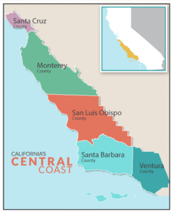 This set is in the Southern California part of what we call the Central Coast (see map to the left). One could continue northward and see some more amazing scenery, including some lovely beaches such as those at Morro Bay and San Simeon, visit Hearst Castle and then do the spectacular (if a bit harrowing) drive along Highway 1 to Big Sur and then Carmel, Monterey and Santa Cruz. After a closure of almost two years due to land slides Highway 1 has reopened! Read more here. There are two more northern counties along the Central Coast – Monterey County and Santa Cruz County. The plan in the blog, however, is to stay south and cut over from Pismo Beach via San Luis Obispo to get to the San Joaquin Valley – where the Joads wound up once they made it to California on Route 66 in the Grapes of Wrath.
So next post we are going to be leaving the coast and heading eastward. We’ll make our way to Highway 99 and the heartland to drive northward as far as the Lincoln Highway in the Delta and see along the way a very different part of the state. The California agricultural heartland away from the coastal bubbles.
Here is the set. Click on (or tap) an image to expand it (and use the arrow to the right on an expanded image to go through the set, if preferred over scrolling down in the post).
Catch you on the next wave.
 in the Oxnard downtown, Ventura County")
The now closed Vogue Theater (1950) in the Oxnard downtown, Ventura County

Sabor, Oxnard, Ventura County. "Best fish tacos in Oxnard."
, Ventura")
Mission San Buenaventura (founded 1782), Ventura
, Ventura")
Mission San Buenaventura (founded 1782), Ventura
, Ventura")
Mission San Buenaventura (founded 1782), Ventura

"Mission Bell Marker" on the historic El Camino Real route through Ventura at Mission Park
")
Ventura Pier Beach and Pierpont Bay, Ventura (from the Ventura Promenade pathway to Surfers Point Park)

San Buenaventura City Pier, Ventura

San Buenaventura City Pier, Ventura

Butterfly Beach, Montecito, Santa Barbara County
, Santa Barbara")
Arroyo Burro Beach (a/k/a Hendry's Beach), Santa Barbara
, Santa Barbara")
Arroyo Burro Beach (a/k/a Hendry's Beach), Santa Barbara

Mission Santa Barbara, founded 1786 - the queen of California missions

Mission Santa Barbara, founded 1786

Junípero Serra, the founder of the California Missions, statue at Mission Santa Barbara, founded 1786
, Santa Barbara")
The Arlington Theatre (1931), Santa Barbara
, Santa Barbara")
The Arlington Theatre (1931), Santa Barbara
")
East Beach in Santa Barbara (looking towards Stearns Wharf)

Santa Barbara Harbor

Santa Barbara Harbor

Santa Barbara Harbor

Vintage boats at Santa Barbara Harbor

Vintage 1950s Ford Country Squire "Woody" Station Wagon in Goleta, Santa Barbara County

Vintage 1950s Ford Country Squire "Woody" Station Wagon in Goleta, Santa Barbara County

Goleta Beach County Park & Goleta Pier, Goleta, Santa Barbara County
, Goleta, Santa Barbara County")
Goleta Beach County Park (looking toward the UC Santa Barbara campus at Isla Vista), Goleta, Santa Barbara County
 at Rancho La Patera, Goleta, Santa Barbara County")
Carpenter Gothic: Stow House (1872) at Rancho La Patera, Goleta, Santa Barbara County
 from Los Olivos to Santa Barbara")
The view of Los Padres National Forest from California SR 154 (a/k/a the Chumash Highway and San Marcos Pass Road ) from Los Olivos to Santa Barbara

The tasting room at Foxen Vineyard & Winery in the Santa Barbara wine country

Mission Santa Inés, Solvang, Santa Barbara County

Mission Santa Inés, Solvang, Santa Barbara County

Airstream spotted in Los Alamos, Santa Ynez Valley, Santa Barbara County
, North H St., Lompoc (Santa Barbara County)")
Lompoc Theater (opened 1927, closed in the 1990s), North H St., Lompoc (Santa Barbara County)
")
Lompoc (Santa Barbara County)

Mission La Purísima Concepción, near Lompoc, Santa Barbara County

Mission La Purísima Concepción, near Lompoc, Santa Barbara County

Near Santa Maria, Santa Barbara County
, Santa Maria, Santa Barbara County")
Bill's Take Out (1953), Santa Maria, Santa Barbara County
, Highway 1, Gaudalupe, Santa Barbara County")
The Royal Theater (opened in 1939 and closed in the late 1990s), Highway 1, Gaudalupe, Santa Barbara County
, Gaudalupe, Santa Barbara County")
Car for sale. On Highway 1 (Cabrillo Highway), Gaudalupe, Santa Barbara County

La Simpatia Cafe, Highway 1, Gaudalupe, Santa Barbara County

Rancho Guadalupe Dunes Preserve, Gaudalupe, Santa Barbara County

Rancho Guadalupe Dunes Preserve, Gaudalupe, Santa Barbara County
 historic C.T. Rice House (1885) in Oceano (San Luis Obispo County) - now surrounded by an over 55 mobile home park")
The boarded up (and supposedly haunted) historic C.T. Rice House (1885) in Oceano (San Luis Obispo County) - now surrounded by an over 55 mobile home park

Oceano Dunes by Pismo Beach, San Luis Obispo County

Oceano, San Luis Obispo County

Amtrak Pacific Surfliner, Oceano, San Luis Obispo County

Cruiser. Pismo Beach, San Luis Obispo County

Pismo Beach and Pismo Beach Pier, San Luis Obispo County

Pismo Beach, San Luis Obispo County

Pismo Beach, San Luis Obispo County

Pismo Beach and Pismo Beach Pier, San Luis Obispo County

Pismo Beach, San Luis Obispo County

Pismo Beach, San Luis Obispo County

Shell Beach, San Luis Obispo County

Margot Dodd Park, Shell Beach, San Luis Obispo County

The coast at Shell Beach, San Luis Obispo County

Shell Beach Coastal Conservancy Preserve, San Luis Obispo County

Shell Beach Coastal Conservancy Preserve, San Luis Obispo County

Shell Beach Coastal Conservancy Preserve, San Luis Obispo County

Shell Beach Coastal Conservancy Preserve, San Luis Obispo County

Shell Beach Coastal Conservancy Preserve, San Luis Obispo County

Pismo Beach and Pismo Beach Pier, San Luis Obispo County