
 Buffalo to Tonawanda.
My 2018 drive along the Erie Canalway National Heritage Corridor now starts. In this post in my series on the Erie Canal and upstate New York we will say goodbye to Buffalo and get as far as Niagara County with a few detours along the way.
We’ll get our first glimpses of the canal itself, both a remnant of the original early 19th century canal and the current enlarged barge canal. We’ll also see a maritime museum, a county fair, an Arts & Crafts movement site, a US president’s house, a Wurlitzer organ factory, a carousel museum, Niagara Falls and even a wee bit of Canada. There’s never a dull moment on the roads less travelled (and especially this one).
First, a few more shots of the fantastic Canalside area of the Buffalo waterfront along the Buffalo River. The very first photo is the Buffalo Harbor “Main Light” lighthouse from 1833 where the Buffalo River meets Lake Erie in Buffalo near the original western terminus of the Erie Canal. I took the shot from Veterans Park on the Buffalo side of the river. Nearby is a fine maritime museum, the Buffalo and Erie County Naval & Military Park. In the photo one sees the USS The Sullivans (1943), a Fletcher-class destroyer, in the foreground, and a partial view of the USS Little Rock (1945), the last surviving vessel from the Cleveland-class of light cruisers in the world, in the background.
Next to the Naval Park is the site of the original western terminus of the Erie Canal. As the posts progress we’ll learn about more about the Erie Canal and its tremendous importance to the opening of the interior of the United States.
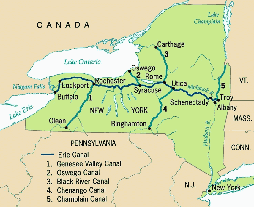
For now here’s a first installment of canal history. The original Erie Canal — 363 miles from Albany to Buffalo, New York – was built between 1817 and 1825 and is said to be the greatest public works project in North America of that era. It was an audacious project and quite an engineering achievement. In the first grouping of photos taken Canalside one sees the “Commercial Slip”, which is where the Erie Canal joined the Buffalo River along what was then known as Little Buffalo Creek. This was the principal transfer point in the early days of the canal for cargo and passengers travelling eastward. Only this small remnant is extant in Buffalo. Inland of the Commercial Slip the path of the early canal through what is now downtown Buffalo is otherwise paved over as it is in many cities along its original routing.
The first thing I learned about the Erie Canal as I read up on it for the journey is that actually there have been three canals commonly referred to as the Erie Canal. There’s the original canal built 1817-1825 (canal #1) and then what resulted from the “First Enlargement” program to improve the canal which started in 1834 and was largely completed by 1862 (canal #2). The original canal was widened and deepened, existing locks were widened, and new locks and aqueducts were constructed. The canal was straightened and even re-routed in some stretches; some segments of the original 1825 canal were abandoned. The 19th century reconfiguration of the canal created during the First Enlargement is called the “Improved Erie Canal” or the “Old Erie Canal” to distinguish it from the waterway’s current iteration.
An ambitious project begun in 1907 and completed in 1918 transformed the Erie Canal yet again. The towpath was eliminated, and the canal was significantly re-routed, further widened and deepened, with numerous dams and locks newly constructed. Large sections of the “Old Erie Canal” were abandoned. The resulting “New York State Barge Canal” (now known as the “New York State Canal System”) is the successor waterway (canal #3) one sees today. Mostly we will see this canal along the drive, although there will also be photos of what is left of the 19th century canal when I could find it. It’s sort of like finding surviving portions of Route 66 in a way, only there is more of old Route 66 left than there is Old Erie Canal.
Towards the end of the set are two photos taken in Tonawanda (about 15 miles/24 km from Canalside in Buffalo by car) where the 20th century Erie Canal meets the Niagara River. This is now the western terminus.
That’s it for Erie Canal history for the moment.
Before heading northward to the beginning of the canal drive in North Tonawanda we will detour to the south of Buffalo to East Aurora (20 miles/32 km by car) and Hamburg (14 miles/22 ½ km by car).
East Aurora is a gem. It has the quintessential Small Town America downtown main street and, more importantly, is said to be the birthplace of the Arts & Crafts movement in the United States. If one is interested in the Arts & Crafts era, East Aurora is definitely worth a visit. That is what drew me there. (From the Roycroft Campus website verbatim: The Roycroft Campus in East Aurora, New York, is the best preserved and most complete complex of buildings remaining in the United States of the “guilds” that evolved as centers of craftsmanship and philosophy during the late 19th century. The Campus, designated a National Historic Landmark district (NHL) in 1986, contains nine of the original 14 structures including the Inn, the Chapel, the Print Shop, the Furniture Shop, and the Copper Shop.)
East Aurora is also the birthplace of Fisher-Price toys and where the 13th president of the United States, Millard Fillmore, lived for a number of years. Truthfully, I don’t know too much about him. I do know Fisher-Price toys – we purchased a lot of them for the children over the years. The town also seems to be the place for filming Hallmark Christmas movies according to what I read. Who knew?
In Hamburg I attended the Erie County Fair (since 1820!) which is a classic. Something out of a movie called “The Place That Time Forgot” or the like. I am not mocking it when I say that, although for me (having grown up in Berkeley, California) it was a little other-worldly. Great kettle corn.
Besides being the Western Terminus of the Erie Canal North Tonawanda has a very enjoyable carousel museum, the Herschell Carrousel Factory Museum located at the original factory site. That spelling of carousel is not a typo – that’s the name. From Wikipedia verbatim: At one time five carousel builders operated in North Tonawanda. The Allan Herschell Company, and its predecessor the Herschell-Spillman Company, was the most notable of them and operated from 1883 to 1955. The company produced wood carousels into the 1930s.
North Tonawanda is also the former home of a Rudolph Wurlitzer Company organ factory. The “Mighty Wurlitzer” pipe organs were built there. The building has been repurposed. It wasn’t the only Wurlitzer production facility, and the company had its headquarters in Chicago, but the now closed North Tonawanda facility was at one time the largest musical instrument plant in the world.
Check out the photo of the Pendleton Guard Gate on the Erie Canal near Lockport. What is it? According to an article I found online, every winter (before the really cold weather hits), the Erie Canal is closed to water traffic. After closing the Pendleton “guard gates” – two large, green gates that are dropped into the canal to stem the flow of water from the Niagara River – the water levels begin to drop in the canal between Pendleton and Fairport (by Rochester) eight, nine or ten feet or more. It’s intentional. Why? It’s how they get to the lock gates and underwater structures for repair and maintenance during the winter months (otherwise inaccessible during the rest of the year when the canal is in operation). There are other such gate openings at different locations throughout the system. The Pendleton gates also protect the Erie Canal from flood waters potentially coming from the Niagara River and Lake Erie.
The final three photos were taken at Niagara Falls on the Niagara River at the international border between the USA and Canada. On the US side it is a state park. Three shots: one from the US side, one from the Rainbow Bridge (1941) across the Niagara Falls Gorge connecting the cities of Niagara Falls, NY (USA) with Niagara Falls, Ontario (Canada), and one from the Canadian side. It was fairly easy to cross over on the bridge which I did by foot. Well, at least it was in 2018 before all the Covid-related restrictions (and closures) at the US-Canadian international border, of course. The light was waning, and I only spent about 30 or 40 minutes on the Canadian side before I walked back. By the way, the area immediately around the falls on the US side is underwhelming. Tacky and over-commercialized. My English friends would say “naff”. I can’t really comment on the Canadian side as I saw very little of it. The nearby city of Niagara Falls, NY, is very challenged. I was kind of shocked by how bad it looked there.
I should end on a positive note. It was very pretty end-of-the-day light at the falls and fun photography. It was my first time at Niagara Falls, and I can tick that box now. Despite the disappointment of the area around the state park, it’s still an incredible, awe inspiring visit! Five stars!
Next post we will start out in Lockport and start to see a lot more of the Erie Canal and the cities and towns along it.
Click on (or tap) an image to expand it (and use the arrow to the right on an expanded image to go through the set, if preferred over scrolling down in the post).
 at the mouth of the Buffalo River by Lake Erie near the original western terminus of the Erie Canal")
Buffalo Harbor "Main Light" lighthouse (1833) at the mouth of the Buffalo River by Lake Erie near the original western terminus of the Erie Canal

Canalside, Buffalo - Buffalo and Erie County Naval & Military Park

Canalside, Buffalo at the western terminus for the early 19th century original Erie Canal

Canalside, Buffalo looking toward western terminus of the early 19th century original Erie Canal where it meets the Buffalo River

Canalside, Buffalo: looking toward the western terminus of the early 19th century original Erie Canal

Canalside, Buffalo: at the western terminus of the early 19th century original Erie Canal where it meets the Buffalo River

Sailboats and Sail Buffalo Swedish designed fishing huts by the Buffalo River, Canalside, Buffalo

The Aurora Theatre, 1925, East Aurora

Vidler's 5 & 10 Store, E Main St. in East Aurora - largest 5 & 10 store in the world

Vidler's 5 & 10 Store, E Main St. in East Aurora - largest 5 & 10 store in the world
, Arts & Crafts Roycroft Campus in East Aurora")
The Roycroft Inn (1905), Arts & Crafts Roycroft Campus in East Aurora
, Arts & Crafts Roycroft Campus in East Aurora")
The Roycroft Inn (1905), Arts & Crafts Roycroft Campus in East Aurora
, Arts & Crafts Roycroft Campus in East Aurora")
The Roycroft Inn (1905), Arts & Crafts Roycroft Campus in East Aurora
, now an art gallery and gift shop, Arts & Crafts Roycroft Campus in East Aurora")
The Copper Shop (1902), now an art gallery and gift shop, Arts & Crafts Roycroft Campus in East Aurora
, now an art gallery and gift shop, Arts & Crafts Roycroft Campus in East Aurora")
The Copper Shop (1902), now an art gallery and gift shop, Arts & Crafts Roycroft Campus in East Aurora
, now the Town Hall Building, Arts & Crafts Roycroft Campus in East Aurora")
The Chapel (1899), now the Town Hall Building, Arts & Crafts Roycroft Campus in East Aurora
, now the Town Hall Building, Arts & Crafts Roycroft Campus in East Aurora")
The Chapel (1899), now the Town Hall Building, Arts & Crafts Roycroft Campus in East Aurora
 now a museum, Arts & Crafts Roycroft Campus in East Aurora")
The Print Shop building (1902) now a museum, Arts & Crafts Roycroft Campus in East Aurora

Millard Fillmore House, 24 Shearer Avenue in East Aurora, 1826, once the residence of the 13th president of the United States

Erie County farm near Hamburg
, Hamburg NY")
Erie County Fair (est. 1820), Hamburg NY
, Hamburg NY")
Erie County Fair (est. 1820), Hamburg NY
, Hamburg NY")
Erie County Fair (est. 1820), Hamburg NY
, Hamburg NY")
Erie County Fair (est. 1820), Hamburg NY
, Hamburg NY")
Erie County Fair (est. 1820), Hamburg NY
, Hamburg NY")
Erie County Fair (est. 1820), Hamburg NY
, Hamburg NY")
Erie County Fair (est. 1820), Hamburg NY
")
Tonawanda and North Tonawanda - the "Western Gateway to the Erie Canal" (at the conjuncture of the Erie Canal and the Niagara River)
")
Tonawanda and North Tonawanda - the "Western Gateway to the Erie Canal" (at the conjuncture of the Erie Canal and the Niagara River)
, North Tonawanda")
The Wurlitzer Building (formerly the Rudolf Wurlitzer Company building), North Tonawanda
, North Tonawanda")
The Wurlitzer Building (formerly the Rudolf Wurlitzer Company building), North Tonawanda

Restored lobby inside the Wurlitzer Building, North Tonawanda

Restored lobby inside the Wurlitzer Building, North Tonawanda
")
The Riviera Theatre, North Tonawanda, 1926 (with its fully restored “Mighty Wurlitzer” theatre organ being one of two original Wurlitzer demonstrator organs)
")
The Riviera Theatre, North Tonawanda, 1926 (with its fully restored “Mighty Wurlitzer” theatre organ being one of two original Wurlitzer demonstrator organs)

Herschell Carrousel Factory Museum, North Tonawanda

Herschell Carrousel Factory Museum, North Tonawanda

Herschell Carrousel Factory Museum, North Tonawanda

Herschell Carrousel Factory Museum, North Tonawanda

Herschell Carrousel Factory Museum, North Tonawanda

Herschell Carrousel Factory Museum, North Tonawanda

Herschell Carrousel Factory Museum, North Tonawanda

Herschell Carrousel Factory Museum, North Tonawanda

Martinsville, North Tonawanda

Erie Canal , Pendleton Guard Gate near Lockport

Niagara Falls: American and Canadian Falls from the American side

Niagara Falls: American Falls from Canada

Niagara Falls: American and Canadian Falls from Rainbow Bridge