
The North Carolina Coast
 Hi everyone. I hope you are enjoying the holiday season.
It’s time again for another post from the trip to the US South. I had planned to finish the series by the end of the year, but it seems that is not going to happen. This is the second-to-last in the series featuring images from the drive northward as I pretty much hugged the North Carolina coastline (with just a few detours inland). We will start out in the far south at Ocean Isle Beach just across the state line from South Carolina and make it all the way to Corolla at the edge of the Currituck National Wildlife Refuge at the Outer Banks in the north near the Virginia state line.
This was a very satisfying part of the road trip. Quiet beaches, lots of historic towns, more plantations, the beautiful barrier islands of Cape Fear and the Outer Banks, lighthouses, sand dunes, marshes, Pepsi-Cola and much more. Big chunks of the NC coast have been set aside as protected areas part of either the US National Park Service or the North Carolina Division of Parks and Recreation. Bravo! What a fantastic drive. The weather didn’t always cooperate, but that is a good thing for photography. Lots of dramatic cloud cover, with lovely sunrises and sunsets.
I am writing this from the western US (from southern California) where the sun sets by the ocean in the west. I have spent most of my life in California and got used to sunsets at the coast. Even though I have had a place in New York for several years now, I still find it odd to see the sun rising at the coast. Anyway, one gets used to it. It means getting up early for sunrise shots by the water with a coffee thermos rather than ending the day by the beach with a drink as the sun sets at the Pacific. My favorite sunrise was when I did a stopover in Kitty Hawk (see below).

Here we go. The first photos are from Ocean Isle Beach in the far south of the state in what is called the Cape Fear region. It’s a barrier island along the Intercoastal Waterway and part of the South Brunswick Islands. Really quiet beaches, beautiful marsh savannas, not over developed…a fine first stop. To the left is the southern part of the coast.
Next, after a stop at the Poplar Grove Plantation, a peanut plantation by the Topsail sound in Scotts Hill near Wilmington in Pender County, we will take a look at Beaufort in Carteret County in the “Inner Banks” region. This one is a gem. It is a part of the NC coast called the “Crystal Coast”. Beaufort dates back to 1709. Lots and lots of surviving historic architecture, a busy and seemingly thriving main street and a fine place for a walkabout. Loved it.
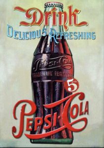
I wound up staying in New Bern about 40 miles (64 km) away from Beaufort. The birthplace of Pepsi-Cola! Who knew? I didn’t until that stop. Lots more historic homes, Tryon Palace (once the official residence and administrative headquarters of the British governors of North Carolina) and other colonial buildings, and another very nice town for a walkabout. I had an ice cream float (with Pepsi, of course) at the “Birthplace of Pepsi Store” at the actual site where Pepsi-Cola was first invented by Caleb Bradham in his pharmacy in 1898. Life’s simple pleasures.
After New Bern I cut inland as I headed for my main destination on the drive, the Outer Banks. A couple of the photos below from that part of the drive were also in the previous black and white set, if they look familiar.
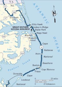 I crossed over to the Outer Banks on US Route 64 via Roanoke Island. Yes, that Roanoke – the site of the vanished first English colony in what is now the USA, Roanoke Colony (1587). One of America’s oldest unsolved mysteries.
I stayed for a couple of days at the Outer Banks – a 200-mile-long (320 km) string of barrier islands and spits off the coast of North Carolina and southeastern Virginia. Sometimes travel destinations do not live up to the hype, but this area sure did. Lots and lots to see and do. I stayed in Kitty Hawk not far from where the Wright brothers made the first controlled powered airplane flights at Kill Devil Hills, four miles (6 km) south of the town, on December 17, 1903. Jockey’s Ridge State Park is the location of the tallest sand dune on the US East Coast, fluctuating between 60 and 100 feet (18 – 30 m) tall. Of the two lighthouses I visited, I climbed up the stairs in one of them (the Currituck Beach Light – 220 steps). What an incredible view of Currituck Sound and the Atlantic Ocean. I will return again to the Outer Banks, that’s for sure.
After the Outer Banks I took US 158 to the mainland and headed for colonial Williamsburg, Virginia, which along with Jamestown and the Route 5 Byway along the James River, will be the subject in a few weeks of the next (and final) post covering the US South. See you again soon for that. In the meantime, all best wishes for the New Year!
Click on (or tap) an image to expand it (and use the arrow to the right on an expanded image to go through the set, if preferred over scrolling down in the post).

Ocean Isle Beach, Brunswick County, North Carolina

Ocean Isle Beach, Brunswick County, North Carolina

Ocean Isle Beach, Brunswick County, North Carolina

Ocean Isle Beach, Brunswick County, North Carolina

Poplar Grove Plantation, a sweet potato and peanut plantation in Scotts Hill near Wilmington, Pender County, North Carolina

Poplar Grove Plantation, a sweet potato and peanut plantation in Scotts Hill near Wilmington, Pender County, North Carolina

Beaufort, Carteret County, in the North Carolina "Inner Banks"

Beaufort, Carteret County, in the North Carolina "Inner Banks"

Beaufort, Carteret County, in the North Carolina "Inner Banks"

Beaufort, Carteret County, in the North Carolina "Inner Banks"

Beaufort, Carteret County, in the North Carolina "Inner Banks"

Beaufort, Carteret County, in the North Carolina "Inner Banks"

Neuse River marina, New Bern in Craven County, North Carolina

Mural in New Bern in Craven County, North Carolina
, 602 Middle Street, New Bern in Craven County, North Carolina")
W.B. Blades House (1907), 602 Middle Street, New Bern in Craven County, North Carolina

Tryon Palace, New Bern in Craven County, North Carolina

George W. Dixon House, Tryon Palace Historic Site, New Bern in Craven County, North Carolina
, New Bern in Craven County, North Carolina")
The John Wright Stanly House (1779), New Bern in Craven County, North Carolina

Christ Church, New Bern in Craven County, North Carolina

Baxter Clock at the former Baxter's Jewelry Store, Pollock St., New Bern in Craven County, North Carolina

The Birthplace of Pepsi-Cola Store, New Bern in Craven County, North Carolina

The Birthplace of Pepsi-Cola Store, New Bern in Craven County, North Carolina

The Birthplace of Pepsi-Cola Store, New Bern in Craven County, North Carolina

The Birthplace of Pepsi-Cola Store, New Bern in Craven County, North Carolina
, Pollocksville in Jones County, North Carolina")
Foscue Plantation (1824), Pollocksville in Jones County, North Carolina

Trenton, Jones County, North Carolina

Crossing the Coastal Plain through Jones and Lenoir Counties on North Carolina Highway 58

Crossing the Coastal Plain through Jones and Lenoir Counties on North Carolina Highway 58

Robersonville, Martin County, in North Carolina's "Inner Banks" region

Cape Hatteras National Seashore near Bodie Island Lighthouse, the Outer Banks, North Carolina
, Cape Hatteras National Seashore, the Outer Banks, North Carolina")
Bodie Island Lighthouse (1872), Cape Hatteras National Seashore, the Outer Banks, North Carolina

Cape Hatteras National Seashore near Bodie Island Lighthouse, the Outer Banks, North Carolina

Cape Hatteras National Seashore near Bodie Island Lighthouse, the Outer Banks, North Carolina

Jockey's Ridge State Park, Nags Head, the Outer Banks, North Carolina

Jockey's Ridge State Park, Nags Head, the Outer Banks, North Carolina

Jockey's Ridge State Park, Nags Head, the Outer Banks, North Carolina

Jockey's Ridge State Park, Nags Head, the Outer Banks, North Carolina

Reconstructed airplane hangar and the brothers' living quarters, Wright Brothers National Memorial, Kill Devil Hills, the Outer Banks, North Carolina
, Wright Brothers National Memorial, Kill Devil Hills, the Outer Banks, North Carolina")
Kill Devil Hill Monument (1932), Wright Brothers National Memorial, Kill Devil Hills, the Outer Banks, North Carolina

Sculpture of the Wright brothers' first flight in the 1903 Flyer, Wright Brothers National Memorial, Kill Devil Hills, the Outer Banks, North Carolina
, Wright Brothers National Memorial, Kill Devil Hills, the Outer Banks, North Carolina")
"Mission 66" Visitor Center (1957 design by Ehrman Mitchell and Romaldo Giurgola), Wright Brothers National Memorial, Kill Devil Hills, the Outer Banks, North Carolina

Dawn at Kitty Hawk Pier, the Outer Banks, North Carolina

Dawn at Kitty Hawk Beach, the Outer Banks, North Carolina

Currituck Beach Lighthouse, Corolla, the Outer Banks, North Carolina

Currituck Beach Lighthouse, Corolla, the Outer Banks, North Carolina

The Lighthouse Keepers' House and Currituck Sound from the Currituck Beach Lighthouse, Corolla, the Outer Banks, North Carolina

Whalehead, Corolla, the Outer Banks, North Carolina

Whalehead, Corolla, the Outer Banks, North Carolina

Whalehead, Corolla, the Outer Banks, North Carolina