
 The return journey begins, March 2017.
Back on the road. After a driving break in the SF Bay Area (much needed after over a month on Route 66) and car servicing I started the long trek back to New York. On the return my plan was to follow the path of the historic Lincoln Highway as much as I could. As is the case with Route 66, much of the original road is now freeways and highways, although it is possible to get on surviving stretches (albeit not to the same extent as Route 66).
Driving in an eastward direction the previous Lincoln Highway posts from 2016 and before got us as far as Stockton (on the 1913 alignment) and Vacaville (on the 1928 alignment). This post will get us to Sacramento picking up from both Lodi (just past Stockton) and Dixon (off I-80 past Vacaville).
On my drive in March 2017 I said goodbye to the Bay Area, got on I-80 in Berkeley and did my first stop in Dixon, a quintessential little California farm town, and then continued on to Sacramento via Davis.
In this post, however, we will start with some photos from Lodi taken in April and November 2016. There’s a fine collection of throwback motels in Lodi with an impressive surviving cluster of them on So. Cherokee Lane. The Sunset Theater opened in 1950 and closed in 1997, and it faces an uncertain future, as I understand it. Great sign! They are producing some very drinkable wine in the Lodi region, including some excellent Zins; one of these days I will spend some meaningful time visiting the wineries around there.
Before we return to March 2017 in this post I will share a grouping of 2016 photos taken close to Lodi in November last year: the snow cranes at the Woodbridge Ecological Reserve (a/k/a the Isenberg Crane Reserve). Read more here and here. An extraordinary sight. I have a good friend who does a lot of birding. I never really got it until I saw these magnificent birds all coming in at dusk (together with an army of other photographers). If only I had been driving that day with a better telephoto and a tripod! I shall return with a faster long lens.
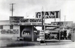 Now let’s return to 2017 and get on the 1928 route of the Lincoln. First, Dixon. A classic. These were all taken on a Sunday morning, and the streets were very quiet. A pretty Carnegie Library, a main street hanging in there (just barely), a typical roadside fruit stand and even a rare extant Giant Orange stand – one of only 16 original orange stands surviving. (We also saw one together on Route 66 on Foothill in southern California in a post earlier in March 2017 as we drove to Pasadena from San Bernardino.) The most recent business at the Giant Orange was a Mr. Taco (now closed). There’s a relatively fresh coast of paint on the Dixon orange, and it seems to be hanging in there. The historic photo opposite is of one of these in Tracy (also a Lincoln Highway city).
At Dixon we will stay off I-80 and follow the original routing to Davis through the California heartland (after an obligatory stop at the iconic Milk Farm sign which still stands).
Before it morphed into Route 40 and later I-80, the Lincoln went directly through Davis at one point, approaching the city from the west via what is now Russell, passing the original entrance to UC Davis. It then made a right on “B” followed by a left on 1st and then took Olive Drive out of the city (after passing under the Richards Boulevard underpass) to follow what is now County Road 32A parallel to I-80.
Explore the UC campus in Davis by clicking here. UCD certainly has changed. I was struck by how much has been built there at the campus and barely recognized it (not having been there in a number of years).
The handsome Old City Hall in Davis (pictured – right after the frat house shot) was built in 1938 in the Spanish Colonial Revival style. The Varsity (built 1949-1950) is a late example of Streamline Moderne art deco and, as I understand, it is still thriving as a single screen theater, although not without having had its share of challenges in the interim. Davis seems to be doing pretty well for itself. One theme I have seen over and over again on my drives on the roads less traveled is that having a university or college in or close to these towns and cities in the heartland makes a huge difference.
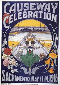
Two things made the 1928 re-routing of the Lincoln Highway the best way to drive from Sacramento to the SF Bay Area (rather than the more roundabout drive via Stockton, Tracy and Livermore to Oakland): the Yolo Bypass Causeway (the original would have been 100 last year) and the Carquinez Bridge. The most important of the two was the causeway bridging the quagmire (opened in 1916) but it wasn’t until the completion of the first single cantilever bridge over the Carquinez Strait (built in 1927) that the Lincoln was re-routed.
Until the causeway was constructed the marshland was impassable for motorists for a good portion of the year when the Sacramento River flooded the Yolo Basin west of Sacramento in winter and spring. Even in the summer months when the flood waters subsided and the marshland dried out, what some have called a “precariously passable” road called the Tule Jake Road was the only way to cross the Yolo Basin going west. The original causeway used by the Lincoln was demolished in 1962; what you see in the pictures in this set is the replacement built for I-80 (the original was just north of the freeway).
There is a big wildlife conservation area right by the modern version of the causeway. I got off I-80 on the western side to take the causeway photos in this set; just before the causeway is the Vic Fazio Yolo Wildlife Area (part of the larger the Yolo Bypass Wildlife Area).
From there we will cross over on the causeway and then head for Sacramento after getting off the freeway and on the Lincoln taking West Capitol Avenue through West Sacramento to the Sacramento River, the principal river of Northern California and the largest river in California. I have to say that West Sacramento has seen better days. There aren’t many surviving old roadside business and motels; very few, to tell you the truth, and what is there is not that photogenic. Scruffy. It’s not that pleasant a drive.
At the river the handsome 1936 Streamline Moderne Tower Bridge awaits; it’s our crossing point. It is a vertical lift bridge across the Sacramento River, linking West Sacramento in Yolo County to the west, with the capital of California, Sacramento, in Sacramento County to the east. The last pix in this set were all taken in the Old Sacramento State Historic Park just across the bridge in Sacramento which has a number of surviving 19th century buildings with some going all the way back to the Gold Rush. It’s a great stop. The California State Railroad Museum there is fantastic. When we were living in northern California I went there a number of times with the family when the children were younger. Once we took the train there from the Amtrak station in Berkeley. It was (and is) a fun day out. There’s much to see and do around there including the Crocker Art Museum and the California Automobile Museum.


")


